Soil
Maps
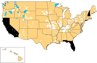
Soils with acetochlor use restrictions are shown on the map below as orange shaded areas. To see if any restricted soils are present in your area use the interactive map viewer. When the interactive map opens, any region with potential soil restrictions are shaded orange. As you zoom in to an area of interest, potentially restricted soils that meet the criteria below will appear.
- Sands with less than 3 percent organic matter;
- Loamy sands with less than 2 percent organic matter; or
- Sandy loams with less than 1 percent organic matter.

Click the image above to launch the interactive map viewer where you can quickly navigate to your area of interest. Use either the zoom-to-county tool or zoom-to-latitude/longitude tool. Both tools are located below the map.
Information on Hawaii is now available.
For areas without mapping data, use a recent soil test to confirm texture and organic matter.


